



NEW YORK — September 5, 2026
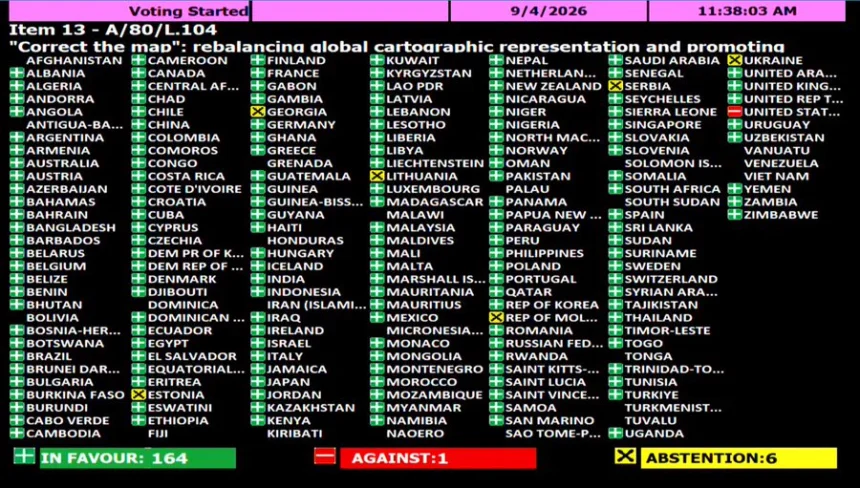
The United States has found itself alone at the United Nations after becoming the only country to vote against an African-led resolution calling for a more accurate representation of the world’s continents.
The UN General Assembly voted overwhelmingly to promote the Equal Earth projection, a map designed to represent the relative size of continents more accurately than the centuries-old Mercator projection.
The vote was 164 in favour, six abstentions and one against — the United States.
The result represents a remarkable diplomatic victory for African countries, which have argued that the familiar world map makes Africa appear dramatically smaller than it actually is.
Why Africa wanted the map changed
The Mercator projection dates back to 1569 and was originally created for maritime navigation.
Its major weakness is that it dramatically enlarges land masses as they move toward the North and South Poles.
The result is a world map in which Greenland can appear almost comparable in size to Africa.
In reality, Africa is about 14 times larger than Greenland.
The Equal Earth projection corrects much of this distortion.
Africa becomes substantially larger on the map, while Europe and North America appear smaller in proportion to their actual land area.
The United States says no
Washington’s opposition has become one of the most striking elements of the vote.
U.S. Ambassador to the United Nations Mike Waltz dismissed the initiative as part of a broader ideological agenda and questioned why the General Assembly was spending time debating historical cartographic issues.
He argued that such resolutions distract the United Nations from more serious international challenges and contribute to what Washington sees as the organization’s declining credibility.
The American position put the United States on the opposite side of an issue supported by virtually the entire international community represented in the vote.
Africa wins the diplomatic battle
The initiative was spearheaded by Togo and backed by the African Union’s 55 member states.
Togo’s Foreign Minister Robert Dussey framed the campaign around a simple principle: “A fair world begins with a fair map.”
For African governments and activists, the issue is about more than cartography.
They argue that maps influence how people understand the world from childhood and that repeatedly seeing Africa visually minimized can reinforce outdated assumptions about the continent’s importance and scale.
The campaign has consequently become linked to broader debates over colonial legacies and how Africa is represented internationally.
A map cannot change reality — but it can change perception
There is an important distinction.
The Mercator projection was not created to deliberately make Africa look insignificant. Its design was primarily intended to assist navigation.
Nor does the UN resolution legally ban Mercator maps.
Instead, the resolution encourages governments, schools, international organizations, media organizations and technology companies to consider more accurate alternatives for general-purpose maps.
Mercator can still be useful for navigation.
The controversy is about using it as though it were an accurate picture of the relative size of the world’s continents.
Africa’s size is extraordinary
Once shown through an equal-area projection, Africa’s geographical scale becomes immediately apparent.
The continent could accommodate the United States, China, India, Japan and much of Europe within its enormous landmass.
Yet traditional maps often make Africa appear visually comparable to — or only slightly larger than — Greenland.
That discrepancy has made the map itself a powerful symbol in the campaign for a different understanding of Africa.
The implications go beyond Africa
The UN vote could eventually influence the maps used in classrooms, textbooks, newsrooms and digital services around the world.
France has already announced its adoption of a different projection, the Eckert IV, as part of a broader effort toward more proportionally accurate geographic representation.
Technology companies could ultimately face pressure to reconsider how they display global maps on digital platforms.
That could expose billions of people to a substantially different visual representation of the planet.
A symbolic moment at the UN
The United States’ lone opposition has given the vote an unexpected geopolitical dimension.
An issue that began as a campaign about cartographic accuracy has become another example of a growing divide between Washington and a large part of the international community.
For African countries, the outcome is a rare moment in which the continent successfully placed its own perspective at the center of a global debate.
For Washington, the vote represents something very different — an unnecessary ideological exercise that distracts from the UN’s core responsibilities.
And for the rest of the world, the argument raises a deceptively simple question:
What should the map on the wall actually tell us about the world?
The continents themselves have not changed.
Africa has always been enormous.
What has changed is the decision to show the world just how enormous it really is.